
Atmospheric River Hits Northwest with 8+ Inches Rain, Rivers Rising
TL/DR –
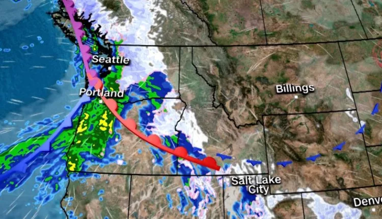
Over 10 million people across the Pacific Northwest are under flood alerts due to a strong atmospheric river causing heavy rainfall in areas already soaking from previous weather events. More than 8 inches of rain has fallen in the region in the last 24 hours, leading rivers to reach flood stage, with some forecasted to reach major flood levels within 24 hours. Areas of particular concern are Washington’s Skagit and Snoqualmie rivers which are predicted to flood roads, farms, and some residential areas.
10 Million Pacific Northwest Residents Under Flood Alert as Heavy Rainfall Continues
Over 10 million people are on flood alert in the Pacific Northwest due to a strong atmospheric river impacting the region. The area, already drenched from previous atmospheric rivers, is bracing for further heavy rainfall.
Already, the region has seen over 8 inches of rain in the last 24 hours. Rivers are rising into flood stage, with several forecasted to reach major flood levels within a day.
In Washington State, the Skagit and Snoqualmie rivers pose significant threat. Predicted to flood roads, farmland and residential areas, these rivers, along with the Skokomish and Grays River, are at moderate to major flood stage.
Further heavy rainfall on Tuesday is expected to worsen the situation in parts of Oregon’s Cascade mountains, southern Washington, and far northwest California. The Weather Prediction Center has marked a Level 2 of 4 risk for excessive rainfall in these areas.
Flood watches cover coastal Oregon and Washington to northeastern Washington and northern Idaho. Although most are set to end Wednesday, some will extend into Thursday.
The Olympic mountains in Washington could get over a foot of rain, while the Cascades may receive 5 to 9 inches, according to the weather service. Coastal residents can expect 3 to 5 inches of rain, with 1 to 3 inches forecasted in the interior lowlands.
Monday and Tuesday’s atmospheric river has already registered impressive totals. Olympic National Park in Washington recorded 8.67 inches in the last 24 hours, with more rain expected.
For those caught in flood conditions, the weather service advises staying indoors, or seeking higher ground if shelter isn’t available.
By Thursday and Friday, storm activity should decrease across most of the Northwest, although showers and high-elevation snow remain possible.
However, the respite from wet weather may be brief. Forecast models indicate another atmospheric river could hit the region by the weekend.
The impact of this potential event will become clearer once this week’s atmospheric river ends on Wednesday.
This back-to-back atmospheric river event, known as an AR family, began Saturday. The lack of recovery time between events significantly increases the risk of flooding.
Parts of Utah and Colorado received snowfall on Monday. Some areas, including Collins, Utah, and Colorado’s Rabbit Ears Pass, reported total snowfall of several feet.
Oregon’s coastline is predicted to be hit with a Level 4 out of 5 atmospheric river event this week. In the far northwestern part of the state, the atmospheric river reached a Level 5 out of 5 Monday night into Tuesday morning.
The latest bout of moisture has also brought warmer temperatures, tying Portland’s all-time high for December at 65 degrees.
The warm temperatures could lead to excessive snowmelt across the Pacific Northwest, increasing the risk of runoff and rising creeks and streams.
Heavy rainfall also heightens the risk of landslides or debris flows, especially in areas affected by wildfires, as the ground is less able to absorb the moisture effectively.
Not all atmospheric river events are harmful. Levels 1 and 2 are often beneficial, providing much-needed rainfall to the western US. However, Levels 4 and 5 pose more risks than benefits, as the dangers of flooding and travel disruptions outweigh the benefits.
—
Read More US News