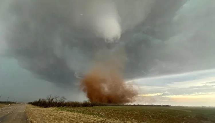
Texas Braces for Severe Weather Before Mardi Gras Parades
TL/DR –
A storm system that once drenched the Pacific Northwest and California is now moving through the Southeast, bringing heavy rainfall and thunderstorms. The heavy rainfall is expected to cause problems particularly for ongoing Mardi Gras festivities, with several Mardi Gras parades in New Orleans forced to adjust their schedules due to the weather. The NOAA’s Weather Prediction Center has highlighted parts of Texas, Arkansas, Louisiana and Mississippi, including New Orleans and Baton Rouge, as being at an increased risk for excessive rainfall and flooding.
Heavy Rainfall Expected Along Interstate 10 Corridor Over the Weekend
Over the weekend, heavy rainfall is set to occur along the Interstate 10 corridor, with New Orleans and Savannah, Georgia likely receiving 2-3″ of rainfall.
New Orleans – The storm system that soaked the Pacific Northwest and California is set to bring heavy rain and thunderstorms to the Southeast. The Storm Prediction Center issued a Severe Thunderstorm Watch for Central Texas, where several tornadoes were reported on Friday.
Despite less instability around the Gulf Coast, heavy rainfall could still cause issues, especially during the Mardi Gras celebrations.
Heavy Rainfall Leads to Flooding Threat and Adjusted Mardi Gras Parade Schedules
The NOAA’s Weather Prediction Center has highlighted southeastern Texas, Arkansas, Louisiana, and Mississippi as areas at increased risk for excessive rainfall and flooding. This includes Baton Rouge and New Orleans, where Mardi Gras celebrations are in full swing.
More than two dozen Mardi Gras parades are scheduled this weekend in New Orleans and are likely to be affected by the expected 3 inches of rain and 35 mph wind gusts.
How much rain will fall?
Forecast models indicate 1-2 inches of rainfall across the South, with some areas potentially seeing as much as 3-4 inches. Several storm systems over the past three weeks have already left between 1-2 feet of rainfall.
These rains have alleviated extreme and exceptional drought conditions in some areas, but Louisiana (88%) and Mississippi (84%) remain unusually dry. The storm system is expected to leave the East Coast by Tuesday morning, but more precipitation could impact the Gulf Coast due to an active El Niño pattern.
Severe Weather Reports
At least two tornadoes were spotted in Texas on Friday, although they are believed to have only been on the ground for a few minutes. No widespread damage or injuries were reported. Additionally, the SPC received several reports of quarter-sized hail and wind gusts of 60 mph.
—
Read More US News
