
Severe Rain Storms and Flood Watches Threaten California
TL/DR –
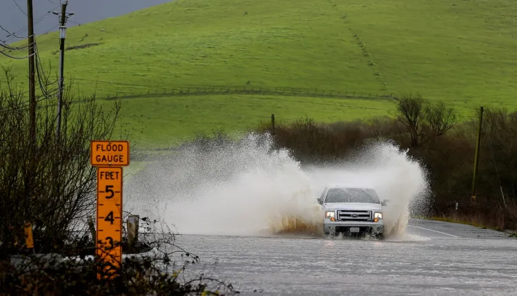
California is experiencing day three of an atmospheric river that is causing heavy rainfall and flooding. Areas between Los Angeles and San Luis Obispo have been hardest hit, with rainfall totals approaching double digits in the mountains north of Santa Barbara. The atmospheric river is expected to weaken by Wednesday evening, but more active weather is expected to return by the weekend.
Atmospheric River Continues to Wreak Havoc in California
California is facing the third day of an atmospheric river’s influence, with moderate to heavy rains causing increasing trouble. Rainfall totals are nearing double digits in the mountains north of Santa Barbara and continued downpours and isolated thunderstorms may worsen the situation.
Flood watches affecting over 35 million people are in place across the coastline from Eureka to the Mexican border, including most of the Central Valley. The risk of additional flooding will persist into Wednesday. Debris flows and mudslides have already occurred, notably in Los Angeles, with high water, mud, and debris forcing numerous road closures in Central and Southern California.
Key places affected include the westbound lanes of the Pacific Coast Highway blocked by a mudslide in Santa Monica and large boulders obstructing both lanes at the intersection of Malibu Canyon Road and Piuma Road in Agoura Hills. Interstate 5 in Burbank also saw temporary blockages due to flooding.
The areas between Los Angeles and San Luis Obispo have been hit hardest. Montecito reported 8.84 inches of rain, while the mountains near Toro Canyon Creek have received 9.71 inches. Most of Ventura County mountains have received at least 6 inches of rain, with 5 inches just north of Malibu and 4.36 inches at Pepperdine University. Downtown Los Angeles has had less rainfall, but more is expected, having already received 11.64 inches of rain this month.
A risk of isolated tornadoes or waterspouts is also present in Southern California, following several tornado warnings in the Sacramento Valley. Some storms have even resulted in snow in the mountains.
Atmospheric River’s Current Location
The atmospheric river, a filament of deep tropical moisture from near Hawaii, is currently being pulled ashore by low pressure stationed off Oregon. It is now aimed at Southern California, with San Diego and Los Angeles in the crosshairs of the moisture plume for most of Tuesday. Behind it, a pocket of frigid air aloft is moving over with the core of the upper-level low pressure. This is expected to cause scattered downpours and possibly some thunderstorms across most of California through Wednesday evening.
An additional 2 to 4 inches of rain is probable in the mountains north of Los Angeles, whereas downtown areas might receive closer to an inch. The issue with this storm is not the rainfall totals, but rather the rainfall rates, potentially topping half an inch per hour.
High Winds and Heavy Snowfall
The central and northern parts of the state have experienced high winds, toppling trees and power lines and leaving over 10,000 customers without power. Snow levels in the Sierra Nevada will drop, leading to greater accumulations at the higher altitudes. In the Southern California mountains, the Weather Service predicts 10 to 20 inches of new snowfall.
The atmospheric river’s influence is expected to wane by Wednesday evening, but active weather looks to return in time for the weekend.
—
Read More US News