
TL/DR –
Severe thunderstorms are expected across Michigan, moving from southwest to northeast, with storms expected to be strongest in the evening and overnight. The storms are predicted to enter southwest Michigan around 8 p.m., expanding in coverage and intensity later in the evening, potentially bringing damaging wind gusts, isolated tornadoes, and large hail. The weather is predicted to switch to snow showers by 8 a.m. Wednesday.
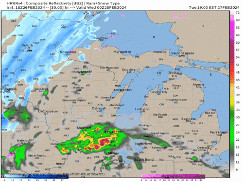
Michigan Severe Thunderstorms Forecast for Tuesday
Severe thunderstorms are expected to sweep across Michigan this Tuesday evening and overnight. From southwest to northeast, all of Lower Michigan should brace for intense storms, according to high-resolution computer models. This is set to be a rare winter stormy evening.

The storm will bring a vigorous one to two-hour round of severe thunderstorms Tuesday evening, followed by a transition to snow showers by 8 a.m. Wednesday.
Here are some key times for severe thunderstorms: By 8 p.m, a cluster of severe storms should be entering southwest Michigan.

By late Tuesday evening, the storms will likely expand in coverage and intensity from Grand Rapids, Ann Arbor, Flint to Detroit.

At midnight, the storms will swing through the Saginaw/Bay City area and northern Lower Michigan, with colder air and snow beginning to swing southeast into the western U.P. and eastern Wisconsin.

These thunderstorms may bring brief damaging wind gusts and large hail, potentially up to two inches in diameter which could cause car damage. There is also a chance of isolated tornadoes. To keep your property safe, it would be advisable to park cars in a garage where available.
Stay updated on Tuesday for any changes to the severe weather forecast here.
—
Read More US News