
Saturday’s Light Snow Precedes Major Storm Monday-Tuesday
TL/DR –
Snow showers are expected in central Iowa over the weekend, with accumulations staying under 1 inch. A more powerful system is set to bring a heavy snowfall across the state from Monday evening into Tuesday, with southern Iowa expected to receive 4-6 inches and the Des Moines area receiving 2-4 inches. The weather conditions will likely make for slippery road conditions for Monday and Tuesday commutes, and temperatures will drop significantly by the end of the week.
Iowa Weather Forecast
Expect off and on snow showers from Saturday night into Sunday with accumulations under 1 inch in central Iowa. By Sunday, anticipate dry skies starting with cloud cover, leading to potential sunshine breaks towards midday. The main focus remains the powerful system approaching the Midwest on Monday and Tuesday, originating from an upper-level wave in the Pacific Northwest.
Snow is possible in far northwest Iowa, Nebraska, and South Dakota late Sunday night into Monday morning. The rest of the state will remain dry until later in the afternoon when a rain/snow mix from the southwest will transition to snow during the evening, spreading throughout the state by Tuesday morning. Southern Iowa is expected to receive the most snowfall, with 4-6″ forecasted. The Des Moines area may anticipate 2-4″, with less in Northern Iowa.
A Winter Storm Watch has been issued for far western and much of southern Iowa from Monday morning through Tuesday afternoon due to heavy snow potential. Closings and Interactive Radar are available for updates.
Temperatures will be in the mid-30s when the snow starts on Monday evening, then fall to around freezing and stay near 32° into Tuesday morning. This could result in wetter snow, particularly in the south, leading to potentially slippery road conditions for Monday and Tuesday commutes. Winds will increase as the snow ends on Tuesday, with northerly winds exceeding 20 mph in the afternoon and gusts up to 40 mph. More snow possibilities follow late Wednesday night/Thursday morning, and next weekend, along with much colder temperatures by the end of next week.
Days Forecast
Sunday: Mostly cloudy morning, possible afternoon sun. High 34F. Winds W at 5-10 mph. Gusts up to 15 mph.
Sunday night: Cloudy skies. Low 28F. Winds ESE at 10-15 mph.
Monday: Cloudy skies. Rain/snow mix in the afternoon, changes to all snow. High 37F. Winds SE at 10-15 mph. Gusts up to 25 mph.
Monday night: Likely overnight snow, heaviest in southern Iowa. Low 29F. Winds NE at 10-15 mph.
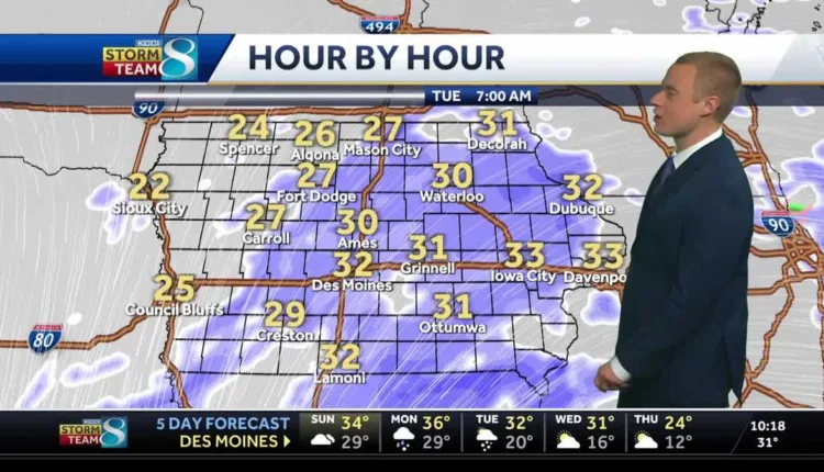
Tuesday: Morning snow, then cloudy and windy. Steady temps in the low to mid-30s. Winds N at 20-25 mph. Gusts up to 40 mph. Des Moines expected to accumulate 2-4″ snow.
Tuesday night: Partly cloudy. Low 18F. Winds NW at 15-20 mph.
—
Read More US News